
Make a donation
Gear up for your next adventure:
As an Amazon Associate, this site earns from qualifying purchases at no extra cost to you.
Cerro Amarillo topographic map
Click on the map to display elevation.
Make a donation
Gear up for your next adventure:
As an Amazon Associate, this site earns from qualifying purchases at no extra cost to you.
Cerro Amarillo
El Cerro Amarillo es un cerro de la ciudad de Concepción, Chile, ubicado entre las calles Rozas y Rengo, que abarca una superficie de 3000 m² y posee 30 metros de altitud. Sobre este se sitúa un parque creado en 1933, actualmente administrado por la Municipalidad de Concepción, que comprende jardines, paseos y miradores rodeados por murallas de mampostería de piedra.
Make a donation
Gear up for your next adventure:
As an Amazon Associate, this site earns from qualifying purchases at no extra cost to you.
About this map
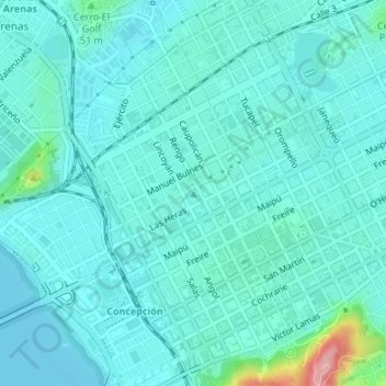
Name: Cerro Amarillo topographic map, elevation, terrain.
Average elevation: 82 ft
Minimum elevation: 16 ft
Maximum elevation: 469 ft
Make a donation
Gear up for your next adventure:
As an Amazon Associate, this site earns from qualifying purchases at no extra cost to you.
Other topographic maps
Click on a map to view its topography, its elevation and its terrain.
La Araucana
Chile > Región del Biobío > Provincia de Concepción > Concepción
Average elevation: 253 ft
Laguna Lo Méndez
Chile > Región del Biobío > Provincia de Concepción > Concepción
Average elevation: 85 ft
Laguna Lo Galindo
Chile > Región del Biobío > Provincia de Concepción > Concepción
Average elevation: 79 ft
Laguna Las Tres Pascualas
Chile > Región del Biobío > Provincia de Concepción > Concepción
Average elevation: 75 ft
Make a donation
Gear up for your next adventure:
As an Amazon Associate, this site earns from qualifying purchases at no extra cost to you.
Parque Ecuador
Chile > Región del Biobío > Provincia de Concepción > Concepción
Average elevation: 164 ft
Laguna Lo Galindo
Chile > Región del Biobío > Provincia de Concepción > Concepción
Average elevation: 79 ft