
Make a donation
Gear up for your next adventure:
As an Amazon Associate, this site earns from qualifying purchases at no extra cost to you.
Manique de Cima topographic map
Click on the map to display elevation.
Make a donation
Gear up for your next adventure:
As an Amazon Associate, this site earns from qualifying purchases at no extra cost to you.
About this map
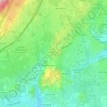
Name: Manique de Cima topographic map, elevation, terrain.
Average elevation: 482 ft
Minimum elevation: 272 ft
Maximum elevation: 902 ft
Make a donation
Gear up for your next adventure:
As an Amazon Associate, this site earns from qualifying purchases at no extra cost to you.
Other topographic maps
Click on a map to view its topography, its elevation and its terrain.
Linhó
Portugal > Lisboa > Sintra (Santa Maria e São Miguel, São Martinho e São Pedro de Penaferrim)
Average elevation: 702 ft
Santa Maria e São Miguel
Portugal > Lisboa > Sintra (Santa Maria e São Miguel, São Martinho e São Pedro de Penaferrim)
Average elevation: 581 ft
Palácio Nacional de Sintra
Portugal > Lisboa > Sintra (Santa Maria e São Miguel, São Martinho e São Pedro de Penaferrim) > Sintra
Average elevation: 745 ft