
Observatory Hill topographic map
Click on the map to display elevation.
About this map
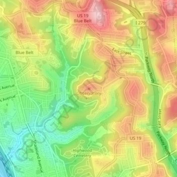
Name: Observatory Hill topographic map, elevation, terrain.
Average elevation: 1,047 ft
Minimum elevation: 725 ft
Maximum elevation: 1,355 ft
Other topographic maps
Click on a map to view its topography, its elevation and its terrain.
Squirrel Hill South
United States > Pennsylvania > Allegheny County > Pittsburgh
Average elevation: 971 ft
Spring Hill-City View
United States > Pennsylvania > Allegheny County > Pittsburgh
Average elevation: 958 ft
Central Northside
United States > Pennsylvania > Allegheny County > Pittsburgh
Average elevation: 866 ft
Point Breeze North
United States > Pennsylvania > Allegheny County > Pittsburgh
Average elevation: 971 ft
Brighton Heights
United States > Pennsylvania > Allegheny County > Pittsburgh
Average elevation: 922 ft
Highland Park Reservoir No. 2
United States > Pennsylvania > Allegheny County > Pittsburgh
Average elevation: 902 ft
Stanton Heights
United States > Pennsylvania > Allegheny County > Pittsburgh
Average elevation: 909 ft
California-Kirkbride
United States > Pennsylvania > Allegheny County > Pittsburgh
Average elevation: 840 ft