
Mount Zirkel topographic map
Interactive map
Click on the map to display elevation.
About this map
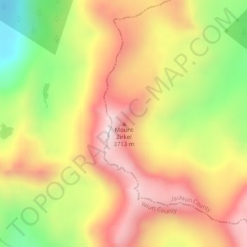
Name: Mount Zirkel topographic map, elevation, terrain.
Location: Mount Zirkel, Jackson County, Colorado, United States (40.83201 -106.66119 40.83211 -106.66109)
Average elevation: 11,020 ft
Minimum elevation: 9,633 ft
Maximum elevation: 12,165 ft
Other topographic maps
Click on a map to view its topography, its elevation and its terrain.
Walden
United States > Colorado > Jackson County
Walden, Jackson County, Colorado, United States
Average elevation: 8,081 ft
Davis Peak
United States > Colorado > Jackson County
Davis Peak, Jackson County, Colorado, United States
Average elevation: 10,650 ft
Cowdrey
United States > Colorado > Jackson County
Cowdrey, Jackson County, Colorado, 80434, United States
Average elevation: 7,917 ft
Continental Divide
United States > Colorado > Jackson County
Continental Divide, Jackson County, Colorado, United States
Average elevation: 11,165 ft
Rand
United States > Colorado > Jackson County
Rand, Jackson County, Colorado, 80473, United States
Average elevation: 8,632 ft
Pitchpine Mountain
United States > Colorado > Jackson County
Pitchpine Mountain, Jackson County, Colorado, United States
Average elevation: 8,376 ft