Geolocate

Real topographic map

Click on the map to display elevation.

👉 Easily get elevation data in JSON, GeoTIFF and KML formats using Elevation API
Thank you for supporting this site ❤️
Make a donation

About this map

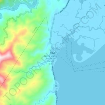
Name: Real topographic map, elevation, terrain.

Location: Real, Quezon, Calabarzon, 4335, Philippines (14.62522 121.56369 14.70522 121.64369)

Average elevation: 423 ft

Minimum elevation: -13 ft

Maximum elevation: 2,648 ft

Gear up for your next adventure:

🍳Camping Cook Set - Complete cookware for outdoor meals
🌡️Portable Weather Meter - Track weather conditions on the trail
🕶️Glacier Sunglasses - Side shields to protect eyes from high-altitude snow glare
🧤Hiking Gloves - Protective gloves for rugged trails
🔭Telescopic Hiking Pole - Adjustable pole for hiking stability

As an Amazon Associate, this site earns from qualifying purchases at no extra cost to you.