Geolocate

Saybrook topographic map

Click on the map to display elevation.

About this map

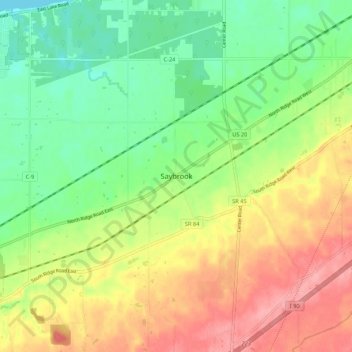
Name: Saybrook topographic map, elevation, terrain.

Location: Saybrook, Ashtabula County, Ohio, United States (41.78777 -80.91180 41.86777 -80.83180)

Average elevation: 702 ft

Minimum elevation: 561 ft

Maximum elevation: 876 ft

Ashtabula County trails, hiking, mountain biking, running and outdoor activities

Other topographic maps

Click on a map to view its topography, its elevation and its terrain.

Roaming Shores

United States > Ohio > Ashtabula County

Average elevation: 883 ft

Rock Creek

United States > Ohio > Ashtabula County

Average elevation: 814 ft

Edgewood

United States > Ohio > Ashtabula County

Average elevation: 702 ft

North Kingsville

United States > Ohio > Ashtabula County

Average elevation: 650 ft

New Lyme Township

United States > Ohio > Ashtabula County

Average elevation: 994 ft

Ashtabula

United States > Ohio > Ashtabula County

Average elevation: 656 ft

Conneaut

United States > Ohio > Ashtabula County

Average elevation: 696 ft

Geneva

United States > Ohio > Ashtabula County

Average elevation: 591 ft

Jefferson

United States > Ohio > Ashtabula County

Average elevation: 935 ft

Gear up for your next adventure:

🧭Orienteering Set - Complete compass and map reading kit
👖Convertible Hiking Pants - Versatile zip-off pants for changing altitudes and temperatures
🧣Merino Neck Gaiters - Multi-functional headwear for wind and sun protection
🗻Climbing Gear Basics - Essential gear for beginner climbers
📚Navigation Handbooks - Master the art of reading topographic maps and using a compass

As an Amazon Associate, this site earns from qualifying purchases at no extra cost to you.