
Make a donation
Gear up for your next adventure:
As an Amazon Associate, this site earns from qualifying purchases at no extra cost to you.
Zelz topographic map
Click on the map to display elevation.
Make a donation
Gear up for your next adventure:
As an Amazon Associate, this site earns from qualifying purchases at no extra cost to you.
Zelz
Historisch gehörte das Rittergut Zelz als Vasallengut zur Herrschaft Pförten. Als Folge des Wiener Kongresses wurde Zelz aus dem Königreich Sachsen in das Königreich Preußen umgegliedert, wo die Gemeinde im Landkreis Sorau im Regierungsbezirk Frankfurt in der Provinz Brandenburg lag. Im Jahr 1826 gehörten zum damaligen Rittergut Zelz (sowohl der heute deutsche als auch der heute polnische Teil) ein Vorwerk, eine herrschaftliche Schäferei, eine Kolonie, eine Wassermühle, eine Bleiche und ein Zollhaus. Der Ort hatte zu diesem Zeitpunkt insgesamt 175 Einwohner in 24 Wohnhäusern und war nach Triebel gepfarrt.[4] In der Topographisch-statistischen Übersicht des Regierungsbezirks Frankfurt a.d.O. aus dem Jahr 1844 wird ein zu Zelz gehörender Dorfkrug mit dem Namen Schneekönig erwähnt. Insgesamt hatte Zelz 230 Einwohner.[5] 1864 lebten in Zelz 182 und in der Kolonie Schneekönig 43 Einwohner.[6]
Make a donation
Gear up for your next adventure:
As an Amazon Associate, this site earns from qualifying purchases at no extra cost to you.
About this map
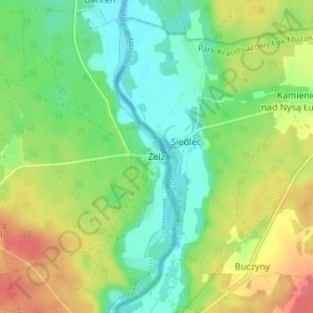
Name: Zelz topographic map, elevation, terrain.
Average elevation: 377 ft
Minimum elevation: 292 ft
Maximum elevation: 505 ft
Make a donation
Gear up for your next adventure:
As an Amazon Associate, this site earns from qualifying purchases at no extra cost to you.
Other topographic maps
Click on a map to view its topography, its elevation and its terrain.