
Kampung Pantai topographic map
Interactive map
Click on the map to display elevation.
About this map
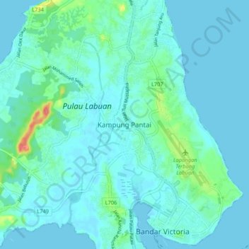
Name: Kampung Pantai topographic map, elevation, terrain.
Location: Kampung Pantai, Labuan, 87000, Malaysia (5.27137 115.19100 5.35137 115.27100)
Average elevation: 33 ft
Minimum elevation: 0 ft
Maximum elevation: 230 ft
Other topographic maps
Click on a map to view its topography, its elevation and its terrain.
Daat Island
Malaysia > Labuan > Labuan > Victoria
Daat Island, Victoria, Labuan, Malaysia
Average elevation: 16 ft
Taman Awam Pantai Tanjung Purun
Malaysia > Labuan > Labuan > Victoria
Taman Awam Pantai Tanjung Purun, Victoria, Labuan, Malaysia
Average elevation: 13 ft
Labuan Bird Park
Malaysia > Labuan > Kampung Pohon Batu
Labuan Bird Park, Kampung Pohon Batu, Labuan, 87000, Malaysia
Average elevation: 43 ft
Kampung Patau-Patau II (Water Village)
Kampung Patau-Patau II (Water Village), Victoria, Labuan, 87009, Malaysia
Average elevation: 23 ft