Geolocate

Floyds Knobs topographic map

Click on the map to display elevation.

About this map

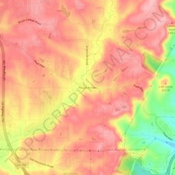
Name: Floyds Knobs topographic map, elevation, terrain.

Location: Floyds Knobs, Floyd County, Indiana, 47146, United States (38.30438 -85.89353 38.34438 -85.85353)

Average elevation: 823 ft

Minimum elevation: 515 ft

Maximum elevation: 961 ft

Floyd County trails, hiking, mountain biking, running and outdoor activities

Other topographic maps

Click on a map to view its topography, its elevation and its terrain.

Galena

United States > Indiana > Floyd County

Average elevation: 761 ft

Greenville

United States > Indiana > Floyd County

Average elevation: 804 ft

Gear up for your next adventure:

👓Polarized Sunglasses - Outdoor sunglasses for glare reduction
🎒Outdoor Daypacks - Lightweight backpacks designed for carrying maps and essential gear
📌Outdoor GPS Map App - Apps and devices for digital topographic navigation
📻Weather Alert Radios - Stay informed of storm risks while off-the-grid
🔭Telescopic Hiking Pole - Adjustable pole for hiking stability

As an Amazon Associate, this site earns from qualifying purchases at no extra cost to you.