Geolocate

Galena topographic map

Click on the map to display elevation.

About this map

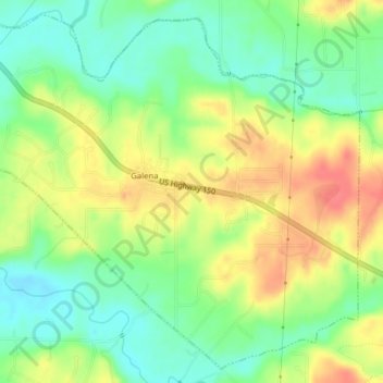
Name: Galena topographic map, elevation, terrain.

Location: Galena, Floyd County, Indiana, United States (38.33619 -85.95879 38.36460 -85.91958)

Average elevation: 761 ft

Minimum elevation: 669 ft

Maximum elevation: 873 ft

Floyd County trails, hiking, mountain biking, running and outdoor activities

Other topographic maps

Click on a map to view its topography, its elevation and its terrain.

Floyds Knobs

United States > Indiana > Floyd County

Average elevation: 823 ft

Silver Hills

United States > Indiana > Floyd County > New Albany

Average elevation: 525 ft

Edwardsville

United States > Indiana > Floyd County

Average elevation: 817 ft

Gear up for your next adventure:

🧭Map Reading Tools - Tools and kits for map navigation
Backpacking Tent - Lightweight and durable tent for multi‑day hikes
🚪Portable Camp Chair - Foldable chair for comfort at camp
🛶Inflatable Kayak - Portable kayak for rivers, lakes, and expeditions
🔋Solar Power Banks - Keep your GPS and phone charged in remote wilderness areas

As an Amazon Associate, this site earns from qualifying purchases at no extra cost to you.