
Make a donation
Gear up for your next adventure:
As an Amazon Associate, this site earns from qualifying purchases at no extra cost to you.
Ladivert topographic map
Click on the map to display elevation.
Make a donation
Gear up for your next adventure:
As an Amazon Associate, this site earns from qualifying purchases at no extra cost to you.
About this map
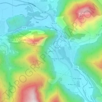
Name: Ladivert topographic map, elevation, terrain.
Average elevation: 2,388 ft
Minimum elevation: 1,572 ft
Maximum elevation: 4,304 ft
Make a donation
Gear up for your next adventure:
As an Amazon Associate, this site earns from qualifying purchases at no extra cost to you.
Other topographic maps
Click on a map to view its topography, its elevation and its terrain.
Saint-Béat
France > Occitanie > Haute-Garonne > Saint-Béat-Lez
La superficie de la commune est de 737 hectares ; son altitude varie de 476 à 1 763 mètres.
Average elevation: 2,861 ft
Lez
France > Occitanie > Haute-Garonne > Saint-Béat-Lez
La superficie de la commune est de 260 hectares. Son altitude minimale, 499 mètres, se situe là où la Garonne quitte la commune pour entrer sur celle de Saint-Béat. L'altitude maximale, 1 180 (ou 1 181) mètres, est atteinte au sud-est, au Rocher du Midi, en limite d'Argut-Dessus, commune associée à Boutx.
Average elevation: 2,362 ft
Saint-Béat
France > Occitanie > Haute-Garonne > Saint-Béat-Lez
La superficie de la commune est de 737 hectares ; son altitude varie de 476 à 1 763 mètres.
Average elevation: 2,861 ft
Make a donation
Gear up for your next adventure:
As an Amazon Associate, this site earns from qualifying purchases at no extra cost to you.