Geolocate

Purulia topographic map

Click on the map to display elevation.

Purulia

Purulia is located at 23°20′N 86°22′E / 23.33°N 86.37°E / 23.33; 86.37. It has an average elevation of 228 metres (748 feet).

Wikipedia (CC-BY-SA 3.0)

About this map

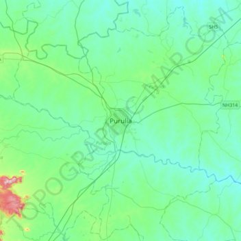
Name: Purulia topographic map, elevation, terrain.

Location: Purulia, Purulia - II, Purulia District, West Bengal, 723101, India (23.16919 86.20724 23.48919 86.52724)

Average elevation: 791 ft

Minimum elevation: 584 ft

Maximum elevation: 1,913 ft

Gear up for your next adventure:

🗻Climbing Gear Basics - Essential gear for beginner climbers
⛑️Personal Locator Beacon - Safety beacon for emergencies
🩹Survival Bandages - High‑quality bandages for emergencies
🪶Trail Camera - Capture wildlife on your hikes
🧤Tactile Hiking Gloves - Keep hands warm while operating GPS and smartphone screens

As an Amazon Associate, this site earns from qualifying purchases at no extra cost to you.