
Make a donation
Gear up for your next adventure:
As an Amazon Associate, this site earns from qualifying purchases at no extra cost to you.
Monte Padrão topographic map
Click on the map to display elevation.
Make a donation
Gear up for your next adventure:
As an Amazon Associate, this site earns from qualifying purchases at no extra cost to you.
About this map
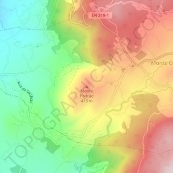
Name: Monte Padrão topographic map, elevation, terrain.
Location: Monte Padrão, Santo Tirso, Porto, 4825-243, Portugal (41.31266 -8.44949 41.31276 -8.44939)
Average elevation: 958 ft
Minimum elevation: 276 ft
Maximum elevation: 1,680 ft
Make a donation
Gear up for your next adventure:
As an Amazon Associate, this site earns from qualifying purchases at no extra cost to you.
Other topographic maps
Click on a map to view its topography, its elevation and its terrain.
Make a donation
Gear up for your next adventure:
As an Amazon Associate, this site earns from qualifying purchases at no extra cost to you.
Santo Tirso, Couto (Santa Cristina e São Miguel) e Burgães
Portugal > Porto > Santo Tirso
Average elevation: 587 ft
Make a donation
Gear up for your next adventure:
As an Amazon Associate, this site earns from qualifying purchases at no extra cost to you.