
Thank you for supporting this site ❤️
Make a donation
Make a donation
Gear up for your next adventure:
As an Amazon Associate, this site earns from qualifying purchases at no extra cost to you.
Aouejiten topographic map
Click on the map to display elevation.
Thank you for supporting this site ❤️
Make a donation
Make a donation
Gear up for your next adventure:
As an Amazon Associate, this site earns from qualifying purchases at no extra cost to you.
About this map
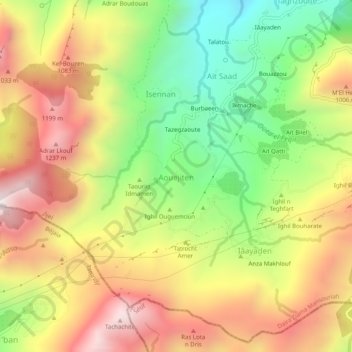
Name: Aouejiten topographic map, elevation, terrain.
Average elevation: 2,549 ft
Minimum elevation: 807 ft
Maximum elevation: 4,298 ft
Thank you for supporting this site ❤️
Make a donation
Make a donation
Gear up for your next adventure:
As an Amazon Associate, this site earns from qualifying purchases at no extra cost to you.
Other topographic maps
Click on a map to view its topography, its elevation and its terrain.
Plage Rouge
Algérie > Jijel > Daïra Ziama Mansouriah > Ziama Mansouriah > Taâzibt > Boulesbiâ
Average elevation: 187 ft
Ighzer n Tourtout
Algérie > Jijel > Daïra Ziama Mansouriah > Ziama Mansouriah > Iâayaden > Anza Makhlouf
Average elevation: 2,549 ft