
Thank you for supporting this site ❤️
Make a donation
Make a donation
Gear up for your next adventure:
As an Amazon Associate, this site earns from qualifying purchases at no extra cost to you.
Frias topographic map
Click on the map to display elevation.
Thank you for supporting this site ❤️
Make a donation
Make a donation
Gear up for your next adventure:
As an Amazon Associate, this site earns from qualifying purchases at no extra cost to you.
About this map
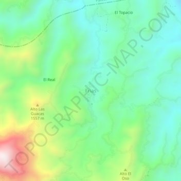
Name: Frias topographic map, elevation, terrain.
Location: Frias, Falan, Norte, Tolima, RAP (Especial) Central, Colombia (5.01147 -75.03401 5.05147 -74.99401)
Average elevation: 4,318 ft
Minimum elevation: 3,589 ft
Maximum elevation: 5,997 ft
Thank you for supporting this site ❤️
Make a donation
Make a donation
Gear up for your next adventure:
As an Amazon Associate, this site earns from qualifying purchases at no extra cost to you.