Geolocate

Springfield topographic map

Click on the map to display elevation.

About this map

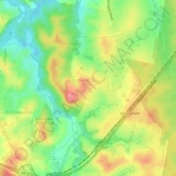
Name: Springfield topographic map, elevation, terrain.

Location: Springfield, Ipswich City, Queensland, 4300, Australia (-27.67459 152.89350 -27.63686 152.92472)

Average elevation: 203 ft

Minimum elevation: 66 ft

Maximum elevation: 358 ft

Gear up for your next adventure:

🛠️Outdoor Gear Repair Kit - Essential tools to fix gear on the trail
🧭Map Reading Tools - Tools and kits for map navigation
🔭Compact Binoculars - HD vision for scouting terrain and identifying distant landmarks
💧Water Purification System - Clean water on the trail with reliable purifiers
🔪Outdoor Multitools - Essential survival tools for gear repair and field use

As an Amazon Associate, this site earns from qualifying purchases at no extra cost to you.