Geolocate

Zebak topographic map

Click on the map to display elevation.

About this map

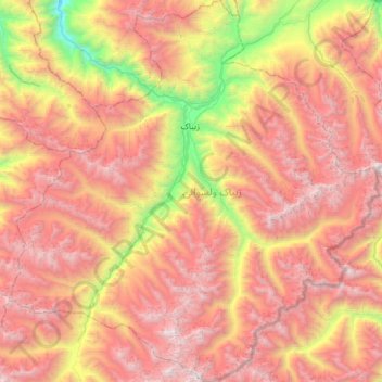
Name: Zebak topographic map, elevation, terrain.

Location: Zebak, Badakhshan Province, Afghanistan (36.20327 71.05288 36.68957 71.64007)

Average elevation: 13,465 ft

Minimum elevation: 7,090 ft

Maximum elevation: 19,104 ft

Other topographic maps

Click on a map to view its topography, its elevation and its terrain.

Rood

Afghanistan > Badakhshan Province > District Zebak

Average elevation: 10,610 ft

Khandud

Afghanistan > Badakhshan Province

Average elevation: 9,557 ft

Korut

Afghanistan > Badakhshan Province > Korut

Average elevation: 11,598 ft

Gear up for your next adventure:

🌄Hiking Binoculars - Compact binoculars for scenic views and trail spotting
📡GPS Antenna Upgrade - Enhance GPS reception in remote terrain
🧭Map Reading Tools - Tools and kits for map navigation
🧺Microfiber Travel Towels - Compact and fast-drying towels for trail use
😴Insulated Sleeping Pads - Compact and warm pads for high-elevation camping

As an Amazon Associate, this site earns from qualifying purchases at no extra cost to you.