
Thank you for supporting this site ❤️
Make a donation
Make a donation
Gear up for your next adventure:
As an Amazon Associate, this site earns from qualifying purchases at no extra cost to you.
Lloret topographic map
Click on the map to display elevation.
Thank you for supporting this site ❤️
Make a donation
Make a donation
Gear up for your next adventure:
As an Amazon Associate, this site earns from qualifying purchases at no extra cost to you.
About this map
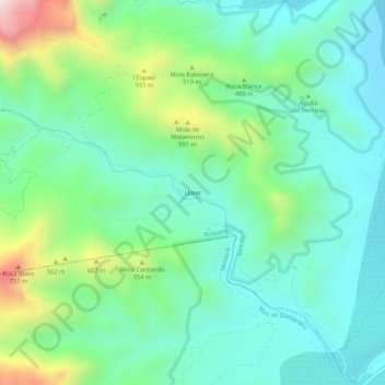
Name: Lloret topographic map, elevation, terrain.
Location: Lloret, Roquetes, Bajo Ebro, Tarragona, Cataluña, 43520, España (40.74725 0.35837 40.78725 0.39837)
Average elevation: 1,188 ft
Minimum elevation: 531 ft
Maximum elevation: 3,035 ft
Thank you for supporting this site ❤️
Make a donation
Make a donation
Gear up for your next adventure:
As an Amazon Associate, this site earns from qualifying purchases at no extra cost to you.