Geolocate

Parvenets topographic map

Click on the map to display elevation.

About this map

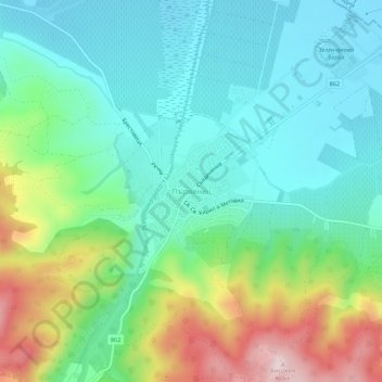
Name: Parvenets topographic map, elevation, terrain.

Location: Parvenets, Rodopi, Plovdiv, 4110, Bulgaria (42.05445 24.64299 42.09445 24.68299)

Average elevation: 951 ft

Minimum elevation: 600 ft

Maximum elevation: 1,801 ft

Other topographic maps

Click on a map to view its topography, its elevation and its terrain.

Западен

Bulgaria > Plovdiv > Plovdiv

Average elevation: 564 ft

Южен

Bulgaria > Plovdiv

Average elevation: 568 ft

Източен

Bulgaria > Plovdiv

Average elevation: 522 ft

Hisaria

Bulgaria > Plovdiv

Average elevation: 1,719 ft

Южен

Bulgaria > Plovdiv

Average elevation: 568 ft

Централен

Bulgaria > Plovdiv

Average elevation: 551 ft

Gear up for your next adventure:

🧭Outdoor Navigation Book - Learn advanced navigation skills
🎒Trail Energy Bars - High‑calorie bars for hiking energy
🧭Map Reading Tools - Tools and kits for map navigation
🪑Portable Camp Table - Compact table for campsite meals
🧢Outdoor Hiking Hat - Sun protection hat for outdoor explorers

As an Amazon Associate, this site earns from qualifying purchases at no extra cost to you.