
Thank you for supporting this site ❤️
Make a donation
Make a donation
Gear up for your next adventure:
As an Amazon Associate, this site earns from qualifying purchases at no extra cost to you.
Orum topographic map
Click on the map to display elevation.
Thank you for supporting this site ❤️
Make a donation
Make a donation
Gear up for your next adventure:
As an Amazon Associate, this site earns from qualifying purchases at no extra cost to you.
About this map
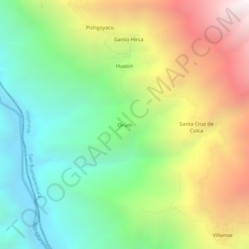
Name: Orum topographic map, elevation, terrain.
Location: Orum, San Buenaventura, Province of Marañón, Huánuco, Peru (-8.81583 -77.20320 -8.77583 -77.16320)
Average elevation: 9,186 ft
Minimum elevation: 6,155 ft
Maximum elevation: 13,816 ft
Thank you for supporting this site ❤️
Make a donation
Make a donation
Gear up for your next adventure:
As an Amazon Associate, this site earns from qualifying purchases at no extra cost to you.