
Make a donation
Gear up for your next adventure:
As an Amazon Associate, this site earns from qualifying purchases at no extra cost to you.
Great Slave Lake topographic map
Click on the map to display elevation.
Make a donation
Gear up for your next adventure:
As an Amazon Associate, this site earns from qualifying purchases at no extra cost to you.
About this map
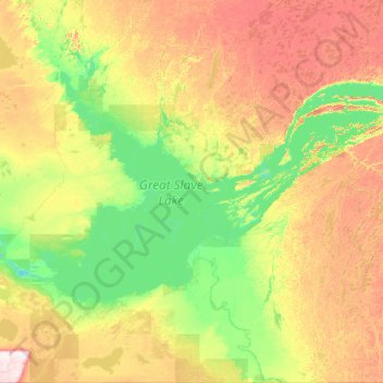
Name: Great Slave Lake topographic map, elevation, terrain.
Location: Great Slave Lake, Northwest Territories, Canada (60.82797 -116.80446 62.95861 -108.89605)
Average elevation: 843 ft
Minimum elevation: 489 ft
Maximum elevation: 2,848 ft
Make a donation
Gear up for your next adventure:
As an Amazon Associate, this site earns from qualifying purchases at no extra cost to you.
Other topographic maps
Click on a map to view its topography, its elevation and its terrain.
Horton Cresent Park
Canada > Northwest Territories > North Slave Region > Yellowknife
Average elevation: 614 ft
Make a donation
Gear up for your next adventure:
As an Amazon Associate, this site earns from qualifying purchases at no extra cost to you.