Geolocate

Mount Morgan topographic map

Click on the map to display elevation.

About this map

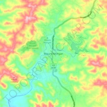
Name: Mount Morgan topographic map, elevation, terrain.

Location: Mount Morgan, Queensland, Australia (-23.68514 150.34831 -23.60514 150.42831)

Average elevation: 984 ft

Minimum elevation: 610 ft

Maximum elevation: 1,509 ft

Other topographic maps

Click on a map to view its topography, its elevation and its terrain.

Mount Morgan

Australia > Queensland > Mount Morgan

Average elevation: 928 ft

Walterhall

Australia > Queensland > Mount Morgan

Average elevation: 951 ft

Mount Morgan

Australia > Queensland > Mount Morgan

Average elevation: 928 ft

Mount Morgan

Australia > Queensland > Mount Morgan

Average elevation: 928 ft

Gear up for your next adventure:

🌎3D Topographic Globes - Raised relief globes for a tactile understanding of geography
🛡️Bear Spray Outdoor - Protection in bear country hikes
🏫Relief Map Kits - Hands-on tools for teaching landforms and elevation
🪶Survival Guide Book - Expert advice for emergency preparedness
🛡️Insect Repellent - Protection against bugs during outdoor activities

As an Amazon Associate, this site earns from qualifying purchases at no extra cost to you.