
Thank you for supporting this site ❤️
Make a donation
Make a donation
Gear up for your next adventure:
As an Amazon Associate, this site earns from qualifying purchases at no extra cost to you.
Wickede (Ruhr) topographic map
Click on the map to display elevation.
Thank you for supporting this site ❤️
Make a donation
Make a donation
Gear up for your next adventure:
As an Amazon Associate, this site earns from qualifying purchases at no extra cost to you.
Wickede (Ruhr)
Höchste Erhebung im Gemeindegebiet ist der Bellingser Berg mit einer Höhe von 238 m über NN. Der tiefste Punkt mit 128 m über NN befindet sich an der Ruhr an der Grenze zwischen Menden (Sauerland) und Fröndenberg/Ruhr.
Thank you for supporting this site ❤️
Make a donation
Make a donation
Gear up for your next adventure:
As an Amazon Associate, this site earns from qualifying purchases at no extra cost to you.
About this map
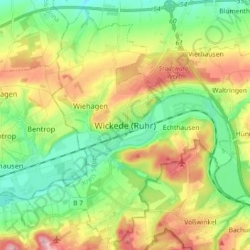
Name: Wickede (Ruhr) topographic map, elevation, terrain.
Average elevation: 577 ft
Minimum elevation: 384 ft
Maximum elevation: 879 ft
Thank you for supporting this site ❤️
Make a donation
Make a donation
Gear up for your next adventure:
As an Amazon Associate, this site earns from qualifying purchases at no extra cost to you.