Geolocate

Green topographic map

Click on the map to display elevation.

About this map

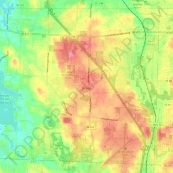
Name: Green topographic map, elevation, terrain.

Location: Green, Summit County, Ohio, United States (40.90650 -81.53644 40.98863 -81.41633)

Average elevation: 1,125 ft

Minimum elevation: 974 ft

Maximum elevation: 1,273 ft

Summit County trails, hiking, mountain biking, running and outdoor activities

Other topographic maps

Click on a map to view its topography, its elevation and its terrain.

Metz

United States > Ohio > Summit County > Stow

Average elevation: 1,043 ft

Little Cuyahoga River

United States > Ohio > Summit County > Akron

Average elevation: 948 ft

Boston

United States > Ohio > Summit County

Average elevation: 804 ft

Maple Grove Park

United States > Ohio > Summit County > Hudson

Average elevation: 1,037 ft

Sagamore Hills

United States > Ohio > Summit County

Average elevation: 866 ft

Copley

United States > Ohio > Summit County

Average elevation: 1,043 ft

Myersville

United States > Ohio > Summit County > Green

Average elevation: 1,122 ft

Decker Park

United States > Ohio > Summit County > Barberton

Average elevation: 997 ft

Metz

United States > Ohio > Summit County > Stow

Average elevation: 1,043 ft

Gear up for your next adventure:

🎒Waterproof Dry Bags - Keep your electronics and maps dry inside your pack
🥤Water Filter Bottle - All‑in‑one filter bottle for safe hydration
🪄Magnetic Compass - Accurate compass for navigation
🧥Men's Rain Shells - Premium waterproof and breathable jackets for mountain weather
🗻Climbing Gear Basics - Essential gear for beginner climbers

As an Amazon Associate, this site earns from qualifying purchases at no extra cost to you.