
Thank you for supporting this site ❤️
Make a donation
Make a donation
Gear up for your next adventure:
As an Amazon Associate, this site earns from qualifying purchases at no extra cost to you.
Anglès topographic map
Click on the map to display elevation.
Thank you for supporting this site ❤️
Make a donation
Make a donation
Gear up for your next adventure:
As an Amazon Associate, this site earns from qualifying purchases at no extra cost to you.
About this map
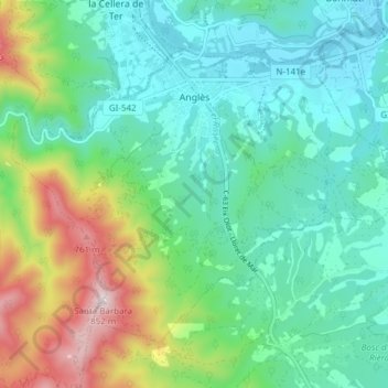
Name: Anglès topographic map, elevation, terrain.
Location: Anglès, la Selva, Gerona, Catalonië, 17160, Spanje (41.91997 2.59989 41.96348 2.67608)
Average elevation: 1,033 ft
Minimum elevation: 417 ft
Maximum elevation: 2,730 ft
Thank you for supporting this site ❤️
Make a donation
Make a donation
Gear up for your next adventure:
As an Amazon Associate, this site earns from qualifying purchases at no extra cost to you.