Geolocate

Dalegarth topographic map

Click on the map to display elevation.

About this map

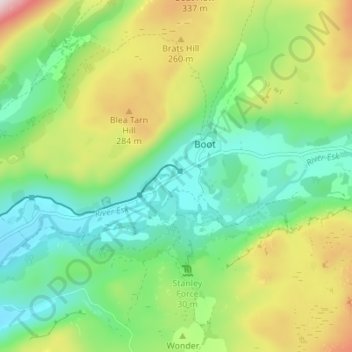
Name: Dalegarth topographic map, elevation, terrain.

Location: Dalegarth, Eskdale, Boot, Cumberland, England, CA19 1TG, United Kingdom (54.37479 -3.29517 54.41479 -3.25517)

Average elevation: 541 ft

Minimum elevation: 75 ft

Maximum elevation: 1,440 ft

Other topographic maps

Click on a map to view its topography, its elevation and its terrain.

Eel Tarn

United Kingdom > England > Cumberland > Boot

Average elevation: 663 ft

Blea Tarn

United Kingdom > England > Cumberland > Boot > Beckfoot

Blea Tarn is a lake in Eskdale, Cumbria, in the English Lake District, located about half a mile north of Beckfoot. Located at an elevation of 217 m (712 ft), the lake has an area of 3.3 hectares (8.2 acres) and measures 277 m × 150 m (909 ft × 492 ft), with a maximum depth of 11 m (36 ft).

Average elevation: 472 ft

Gear up for your next adventure:

🎒Hydration Pack - Hands‑free water reservoir for long hikes
🏕️Tent Footprint - Protect your tent base from wear
🎁Geography Themed Gifts - Unique gift ideas for map lovers and geography enthusiasts
🪑Ultralight Camp Chairs - Portable seating for resting after a long day of mapping
📡Handheld GPS Device - Reliable handheld GPS for outdoor navigation

As an Amazon Associate, this site earns from qualifying purchases at no extra cost to you.