
Mayfield topographic map
Click on the map to display elevation.
About this map
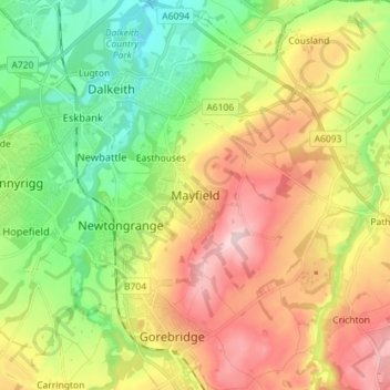
Name: Mayfield topographic map, elevation, terrain.
Location: Mayfield, Midlothian, Scotland, EH22 5EQ, United Kingdom (55.83259 -3.07930 55.91259 -2.99930)
Average elevation: 430 ft
Minimum elevation: 85 ft
Maximum elevation: 886 ft
Other topographic maps
Click on a map to view its topography, its elevation and its terrain.
Straiton Pond Local Nature Reserve
United Kingdom > Scotland > Midlothian > Loanhead
Average elevation: 430 ft