Geolocate

Socorro topographic map

Click on the map to display elevation.

About this map

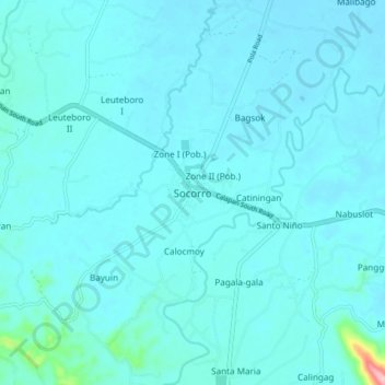
Name: Socorro topographic map, elevation, terrain.

Location: Socorro, Oriental Mindoro, Mimaropa, 5207, Philippines (13.01521 121.36692 13.09521 121.44692)

Average elevation: 66 ft

Minimum elevation: 20 ft

Maximum elevation: 633 ft

Other topographic maps

Click on a map to view its topography, its elevation and its terrain.

Bongabong River

Philippines > Oriental Mindoro

Average elevation: 1,972 ft

Inclanay Dam

Philippines > Oriental Mindoro > Inclanay > Pansulan

Average elevation: 95 ft

Bansud River

Philippines > Oriental Mindoro > Conrazon

Average elevation: 1,132 ft

Naujan Lake

Philippines > Oriental Mindoro > Malabo

Average elevation: 151 ft

Masipit

Philippines > Oriental Mindoro > Calapan

Average elevation: 13 ft

Tawiran

Philippines > Oriental Mindoro > Calapan

Average elevation: 20 ft

Lalud

Philippines > Oriental Mindoro > Calapan > Guinobatan

Average elevation: 26 ft

Gear up for your next adventure:

🪶Trail Camera - Capture wildlife on your hikes
🧢Outdoor Hiking Hat - Sun protection hat for outdoor explorers
🦶Hiking Gaiters - Keep debris and water out of your boots
🛶Inflatable Kayak - Portable kayak for rivers, lakes, and expeditions
🛰️Satellite Messengers - Emergency SOS and two-way messaging for off-grid adventures

As an Amazon Associate, this site earns from qualifying purchases at no extra cost to you.