
天祝藏族自治县 topographic map
Interactive map
Click on the map to display elevation.
About this map
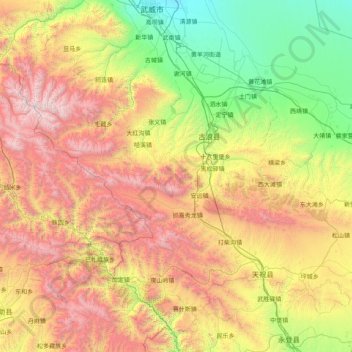
Name: 天祝藏族自治县 topographic map, elevation, terrain.
Location: 天祝藏族自治县, 武威市, 甘肃省, 中国 (36.75112 102.03423 37.89332 103.63432)
Average elevation: 8,868 ft
Minimum elevation: 4,925 ft
Maximum elevation: 15,935 ft
天祝县处于青藏高原、黄土高原和内蒙古高原的交汇地带,境内地势西北高,东南低,海拔在2040-4874米之间。地貌以山地为主,位于县境中部的乌鞘岭横亘东西。
Other topographic maps
Click on a map to view its topography, its elevation and its terrain.