
Make a donation
Gear up for your next adventure:
As an Amazon Associate, this site earns from qualifying purchases at no extra cost to you.
Spy topographic map
Click on the map to display elevation.
Make a donation
Gear up for your next adventure:
As an Amazon Associate, this site earns from qualifying purchases at no extra cost to you.
Spy
La présence de l'Orneau explique la différence importante entre l'altitude la plus basse (85 m) en vallée et l'altitude la plus haute (195 m) sur le plateau.
Make a donation
Gear up for your next adventure:
As an Amazon Associate, this site earns from qualifying purchases at no extra cost to you.
About this map
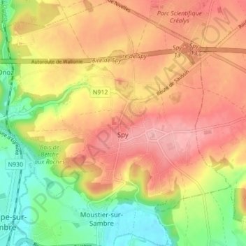
Name: Spy topographic map, elevation, terrain.
Location: Spy, Jemeppe-sur-Sambre, Namur, Wallonie, Belgique (50.46132 4.66703 50.50523 4.73299)
Average elevation: 479 ft
Minimum elevation: 276 ft
Maximum elevation: 640 ft
Make a donation
Gear up for your next adventure:
As an Amazon Associate, this site earns from qualifying purchases at no extra cost to you.
Other topographic maps
Click on a map to view its topography, its elevation and its terrain.
Spy
Belgique > Namur > Namur > Jemeppe-sur-Sambre
La présence de l'Orneau explique la différence importante entre l'altitude la plus basse (85 m) en vallée et l'altitude la plus haute (195 m) sur le plateau.
Average elevation: 479 ft