
Make a donation
Gear up for your next adventure:
As an Amazon Associate, this site earns from qualifying purchases at no extra cost to you.
Triebischtal topographic map
Click on the map to display elevation.
Make a donation
Gear up for your next adventure:
As an Amazon Associate, this site earns from qualifying purchases at no extra cost to you.
Triebischtal
Die Gemeinde lag im namensgebenden Triebischtal und den umliegenden Höhenzügen. Sie befand sich inmitten des östlichen Ausläufers des Erzgebirgsvorlandes zwischen dem Osterzgebirge und der Lommatzscher Pflege.
Make a donation
Gear up for your next adventure:
As an Amazon Associate, this site earns from qualifying purchases at no extra cost to you.
About this map
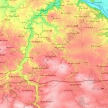
Name: Triebischtal topographic map, elevation, terrain.
Location: Triebischtal, Klipphausen, Meißen, Sachsen, Deutschland (51.03372 13.37294 51.13951 13.49865)
Average elevation: 804 ft
Minimum elevation: 308 ft
Maximum elevation: 1,073 ft
Make a donation
Gear up for your next adventure:
As an Amazon Associate, this site earns from qualifying purchases at no extra cost to you.
Other topographic maps
Click on a map to view its topography, its elevation and its terrain.
Hühndorf
Deutschland > Sachsen > Meißen > Klipphausen
Der Ortskern liegt am oberen Eingang zum engen Tal des Prinzbaches, der in seinem Hühndorfer Quellkessel eine flache Wiesenmulde bildet. Diese Reliefformen verhinderten die Anlage eines Reihendorfes; stattdessen entstand ein Platzdorf mit einer 229 Hektar großen, gelänge-waldhufenähnlichen Streifenflur.…
Average elevation: 876 ft