
Make a donation
Gear up for your next adventure:
As an Amazon Associate, this site earns from qualifying purchases at no extra cost to you.
Keego Harbor topographic map
Click on the map to display elevation.
Make a donation
Gear up for your next adventure:
As an Amazon Associate, this site earns from qualifying purchases at no extra cost to you.
About this map
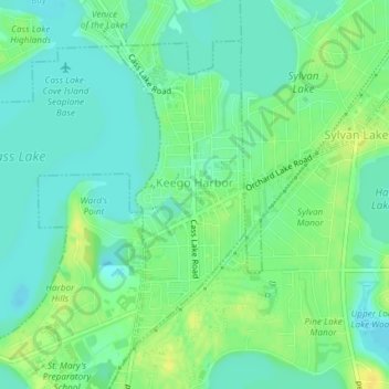
Name: Keego Harbor topographic map, elevation, terrain.
Location: Keego Harbor, Oakland County, Michigan, United States (42.59661 -83.35108 42.61793 -83.33901)
Average elevation: 938 ft
Minimum elevation: 909 ft
Maximum elevation: 978 ft
Make a donation
Gear up for your next adventure:
As an Amazon Associate, this site earns from qualifying purchases at no extra cost to you.
Other topographic maps
Click on a map to view its topography, its elevation and its terrain.
Oakley Park
United States > Michigan > Oakland County > Commerce Charter Township
Average elevation: 925 ft
Make a donation
Gear up for your next adventure:
As an Amazon Associate, this site earns from qualifying purchases at no extra cost to you.