Geolocate

Jerteh topographic map

Click on the map to display elevation.

About this map

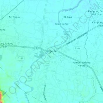
Name: Jerteh topographic map, elevation, terrain.

Location: Jerteh, Besut, Terengganu, 22000, Malaysia (5.69814 102.45715 5.77814 102.53715)

Average elevation: 39 ft

Minimum elevation: 3 ft

Maximum elevation: 217 ft

Other topographic maps

Click on a map to view its topography, its elevation and its terrain.

Pasir Akar

Malaysia > Terengganu > Pulau Redang

Average elevation: 23 ft

Kapas Island

Malaysia > Terengganu

Average elevation: 20 ft

Kuala Nerus

Malaysia > Terengganu

Average elevation: 82 ft

Setiu

Malaysia > Terengganu

Average elevation: 564 ft

Sungai Nerus

Malaysia > Terengganu > Kampung Jeram Hilir

Average elevation: 56 ft

Gear up for your next adventure:

📷Action Camera - Capture your outdoor adventures in HD
Backpacking Tent - Lightweight and durable tent for multi‑day hikes
🦶Carbon Trekking Poles - Reduce knee impact on steep descents with ultra-light poles
🥄Camping Utensil Set - Lightweight utensils for outdoor meals
Backpacking Tents - Weight-optimized shelters for multi-day topographic surveys

As an Amazon Associate, this site earns from qualifying purchases at no extra cost to you.