
Thank you for supporting this site ❤️
Make a donation
Make a donation
Gear up for your next adventure:
As an Amazon Associate, this site earns from qualifying purchases at no extra cost to you.
Lazrou topographic map
Click on the map to display elevation.
Thank you for supporting this site ❤️
Make a donation
Make a donation
Gear up for your next adventure:
As an Amazon Associate, this site earns from qualifying purchases at no extra cost to you.
About this map
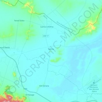
Name: Lazrou topographic map, elevation, terrain.
Location: Lazrou, Daïra de Seriana, Batna, Algérie (35.73356 6.16741 35.87455 6.36786)
Average elevation: 2,746 ft
Minimum elevation: 2,615 ft
Maximum elevation: 4,072 ft
Thank you for supporting this site ❤️
Make a donation
Make a donation
Gear up for your next adventure:
As an Amazon Associate, this site earns from qualifying purchases at no extra cost to you.