
Paal topographic map
Interactive map
Click on the map to display elevation.
About this map
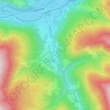
Name: Paal topographic map, elevation, terrain.
Average elevation: 3,881 ft
Minimum elevation: 2,884 ft
Maximum elevation: 5,364 ft
Other topographic maps
Click on a map to view its topography, its elevation and its terrain.
Turrach
Oostenrijk > Stiermarken > Bezirk Murau > Stadl-Predlitz
Turrach, Stadl-Predlitz, Bezirk Murau, Stiermarken, 8862, Oostenrijk
Average elevation: 5,272 ft