
Make a donation
Gear up for your next adventure:
As an Amazon Associate, this site earns from qualifying purchases at no extra cost to you.
Ullastret topographic map
Click on the map to display elevation.
Make a donation
Gear up for your next adventure:
As an Amazon Associate, this site earns from qualifying purchases at no extra cost to you.
About this map
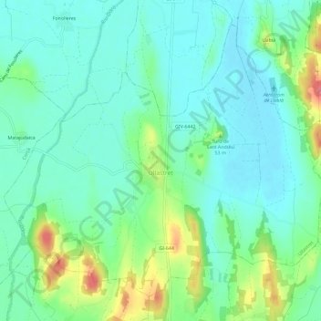
Name: Ullastret topographic map, elevation, terrain.
Location: Ullastret, Bajo Ampurdán, Gerona, Cataluña, 17114, España (41.98458 3.04087 42.02068 3.09849)
Average elevation: 92 ft
Minimum elevation: 13 ft
Maximum elevation: 308 ft
Make a donation
Gear up for your next adventure:
As an Amazon Associate, this site earns from qualifying purchases at no extra cost to you.
Other topographic maps
Click on a map to view its topography, its elevation and its terrain.
Platja d'Aro
España > Cataluña > Bajo Ampurdán > Castillo de Aro, Playa de Aro y S'Agaró
Average elevation: 154 ft
Make a donation
Gear up for your next adventure:
As an Amazon Associate, this site earns from qualifying purchases at no extra cost to you.
Make a donation
Gear up for your next adventure:
As an Amazon Associate, this site earns from qualifying purchases at no extra cost to you.
Cruïlles
España > Cataluña > Bajo Ampurdán > Cruïlles, Monells i Sant Sadurní de l'Heura
Average elevation: 217 ft
Plaça Pepe Rubianes
España > Cataluña > Bajo Ampurdán > Sant Feliu de Guíxols
Average elevation: 154 ft
Make a donation
Gear up for your next adventure:
As an Amazon Associate, this site earns from qualifying purchases at no extra cost to you.
Make a donation
Gear up for your next adventure:
As an Amazon Associate, this site earns from qualifying purchases at no extra cost to you.
Make a donation
Gear up for your next adventure:
As an Amazon Associate, this site earns from qualifying purchases at no extra cost to you.
Monells
España > Cataluña > Bajo Ampurdán > Cruïlles, Monells i Sant Sadurní de l'Heura
Average elevation: 259 ft
Make a donation
Gear up for your next adventure:
As an Amazon Associate, this site earns from qualifying purchases at no extra cost to you.