
Make a donation
Gear up for your next adventure:
As an Amazon Associate, this site earns from qualifying purchases at no extra cost to you.
Jenzig topographic map
Click on the map to display elevation.
Make a donation
Gear up for your next adventure:
As an Amazon Associate, this site earns from qualifying purchases at no extra cost to you.
Jenzig
Der Jenzig bildet das südwestliche Ende eines halbkreisförmigen Höhenzugs, des Hufeisens. Diese bewaldete Hochfläche verläuft vom Jenzig aus nach Osten, über einen Bogen ungefähr auf einer Höhe weiter nördlich und dann wieder nach Westen, wo der Große Gleisberg mit der Kunitzburg das andere Ende bildet. „Im“ Hufeisen liegt ein kleines Nebental des Saaletals sowie die Dörfer und Jenaer Ortsteile Kunitz und Laasan.
Make a donation
Gear up for your next adventure:
As an Amazon Associate, this site earns from qualifying purchases at no extra cost to you.
About this map
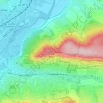
Name: Jenzig topographic map, elevation, terrain.
Location: Jenzig, Jena, Thüringen, 07749, Deutschland (50.93969 11.62707 50.93979 11.62717)
Average elevation: 702 ft
Minimum elevation: 443 ft
Maximum elevation: 1,280 ft
Make a donation
Gear up for your next adventure:
As an Amazon Associate, this site earns from qualifying purchases at no extra cost to you.
Other topographic maps
Click on a map to view its topography, its elevation and its terrain.
Make a donation
Gear up for your next adventure:
As an Amazon Associate, this site earns from qualifying purchases at no extra cost to you.
Make a donation
Gear up for your next adventure:
As an Amazon Associate, this site earns from qualifying purchases at no extra cost to you.