
Thank you for supporting this site ❤️
Make a donation
Make a donation
Gear up for your next adventure:
As an Amazon Associate, this site earns from qualifying purchases at no extra cost to you.
Pianchiosso topographic map
Click on the map to display elevation.
Thank you for supporting this site ❤️
Make a donation
Make a donation
Gear up for your next adventure:
As an Amazon Associate, this site earns from qualifying purchases at no extra cost to you.
About this map
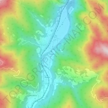
Name: Pianchiosso topographic map, elevation, terrain.
Location: Pianchiosso, Pievetta, Priola, Cuneo, Piemonte, 12071, Italia (44.23647 8.00693 44.27647 8.04693)
Average elevation: 2,359 ft
Minimum elevation: 1,650 ft
Maximum elevation: 3,583 ft
Thank you for supporting this site ❤️
Make a donation
Make a donation
Gear up for your next adventure:
As an Amazon Associate, this site earns from qualifying purchases at no extra cost to you.