
Make a donation
Gear up for your next adventure:
As an Amazon Associate, this site earns from qualifying purchases at no extra cost to you.
Pelham topographic map
Click on the map to display elevation.
Make a donation
Gear up for your next adventure:
As an Amazon Associate, this site earns from qualifying purchases at no extra cost to you.
About this map
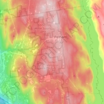
Name: Pelham topographic map, elevation, terrain.
Location: Pelham, Hampshire County, Massachusetts, United States (42.33644 -72.48369 42.42082 -72.35501)
Average elevation: 804 ft
Minimum elevation: 148 ft
Maximum elevation: 1,253 ft
Hampshire County trails, hiking, mountain biking, running and outdoor activities
Make a donation
Gear up for your next adventure:
As an Amazon Associate, this site earns from qualifying purchases at no extra cost to you.
Other topographic maps
Click on a map to view its topography, its elevation and its terrain.
Make a donation
Gear up for your next adventure:
As an Amazon Associate, this site earns from qualifying purchases at no extra cost to you.
Make a donation
Gear up for your next adventure:
As an Amazon Associate, this site earns from qualifying purchases at no extra cost to you.
South Hadley Falls
United States > Massachusetts > Hampshire County > South Hadley
Average elevation: 164 ft
Mill River Recreation Area
United States > Massachusetts > Hampshire County > Amherst > North Amherst
Average elevation: 217 ft
Make a donation
Gear up for your next adventure:
As an Amazon Associate, this site earns from qualifying purchases at no extra cost to you.
Wildwood Conservation Area
United States > Massachusetts > Hampshire County > Amherst
Average elevation: 292 ft
Worthington Corners
United States > Massachusetts > Hampshire County > Worthington
Average elevation: 1,476 ft
Make a donation
Gear up for your next adventure:
As an Amazon Associate, this site earns from qualifying purchases at no extra cost to you.
Make a donation
Gear up for your next adventure:
As an Amazon Associate, this site earns from qualifying purchases at no extra cost to you.