
Make a donation
Gear up for your next adventure:
As an Amazon Associate, this site earns from qualifying purchases at no extra cost to you.
Centro topographic map
Click on the map to display elevation.
Make a donation
Gear up for your next adventure:
As an Amazon Associate, this site earns from qualifying purchases at no extra cost to you.
About this map
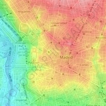
Name: Centro topographic map, elevation, terrain.
Location: Centro, Madrid, Comunidad de Madrid, España (40.40500 -3.72291 40.43054 -3.69046)
Average elevation: 2,110 ft
Minimum elevation: 1,893 ft
Maximum elevation: 2,277 ft
Make a donation
Gear up for your next adventure:
As an Amazon Associate, this site earns from qualifying purchases at no extra cost to you.
Other topographic maps
Click on a map to view its topography, its elevation and its terrain.
Madrid
España > Comunidad de Madrid > Madrid
El casco antiguo, con origen en la medina musulmana, surge de un emplazamiento estratégico (el control de un vado del Manzanares) que determinará una serie de limitaciones topográficas: la disposición del caserío original en las zonas elevadas sobre el río y el barranco de la calle de Segovia, donde se…
Average elevation: 2,133 ft
Make a donation
Gear up for your next adventure:
As an Amazon Associate, this site earns from qualifying purchases at no extra cost to you.
Make a donation
Gear up for your next adventure:
As an Amazon Associate, this site earns from qualifying purchases at no extra cost to you.
Make a donation
Gear up for your next adventure:
As an Amazon Associate, this site earns from qualifying purchases at no extra cost to you.
Make a donation
Gear up for your next adventure:
As an Amazon Associate, this site earns from qualifying purchases at no extra cost to you.
Madrid Río
España > Comunidad de Madrid > Madrid
El río Manzanares se asienta sobre una cuenca de 69 kilómetros que se inicia a 2258 metros de altitud en la sierra de Guadarrama y finaliza en el río Jarama a 527 metros sobre el nivel del mar. En su recorrido recibe el agua de más de treinta arroyos y convive con distintos tipos de infraestructuras, unas…
Average elevation: 2,005 ft
Make a donation
Gear up for your next adventure:
As an Amazon Associate, this site earns from qualifying purchases at no extra cost to you.
Make a donation
Gear up for your next adventure:
As an Amazon Associate, this site earns from qualifying purchases at no extra cost to you.