
Make a donation
Gear up for your next adventure:
As an Amazon Associate, this site earns from qualifying purchases at no extra cost to you.
Portola topographic map
Click on the map to display elevation.
Make a donation
Gear up for your next adventure:
As an Amazon Associate, this site earns from qualifying purchases at no extra cost to you.
About this map
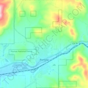
Name: Portola topographic map, elevation, terrain.
Location: Portola, Plumas County, California, 96122, United States (39.79166 -120.49562 39.84994 -120.45297)
Average elevation: 5,151 ft
Minimum elevation: 4,813 ft
Maximum elevation: 6,112 ft
Plumas County trails, hiking, mountain biking, running and outdoor activities
Make a donation
Gear up for your next adventure:
As an Amazon Associate, this site earns from qualifying purchases at no extra cost to you.
Other topographic maps
Click on a map to view its topography, its elevation and its terrain.
Quincy
United States > California > Plumas County > Quincy
Quincy has a Mediterranean climate (Köppen Csb) though its inland location and altitude makes it more continental and wetter than usual for this type, with very heavy snowfalls sometimes occurring in winter – the record being 133 inches (337.8 cm) in the very wet January 1916. Although summer days are hot…
Average elevation: 4,180 ft
Make a donation
Gear up for your next adventure:
As an Amazon Associate, this site earns from qualifying purchases at no extra cost to you.
Little Grass Valley
United States > California > Plumas County > La Porte
About 2.5 miles (4.0 km) north of Little Grass Valley Lake lies a small, natural lily pond called Fowler Lake. Its coordinates are 39°46′27″N 121°00′19″W / 39.77417°N 121.00528°W / 39.77417; -121.00528 (Fowler Lake), and its altitude is 5,446 feet (1,660 m).
Average elevation: 5,394 ft
Make a donation
Gear up for your next adventure:
As an Amazon Associate, this site earns from qualifying purchases at no extra cost to you.
Make a donation
Gear up for your next adventure:
As an Amazon Associate, this site earns from qualifying purchases at no extra cost to you.
Quincy
United States > California > Plumas County
Quincy has a Mediterranean climate (Köppen Csb) though its inland location and altitude makes it more continental and wetter than usual for this type, with very heavy snowfalls sometimes occurring in winter – the record being 133 inches (337.8 cm) in the very wet January 1916. Although summer days are hot…
Average elevation: 4,180 ft
Make a donation
Gear up for your next adventure:
As an Amazon Associate, this site earns from qualifying purchases at no extra cost to you.