
Thank you for supporting this site ❤️
Make a donation
Make a donation
Gear up for your next adventure:
As an Amazon Associate, this site earns from qualifying purchases at no extra cost to you.
Larraun topographic map
Click on the map to display elevation.
Thank you for supporting this site ❤️
Make a donation
Make a donation
Gear up for your next adventure:
As an Amazon Associate, this site earns from qualifying purchases at no extra cost to you.
About this map
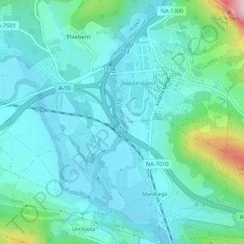
Name: Larraun topographic map, elevation, terrain.
Location: Larraun, Izurdiaga, Irurtzun, Sakana, Navarre, Espagne (42.90362 -1.83940 42.92273 -1.83400)
Average elevation: 1,575 ft
Minimum elevation: 1,385 ft
Maximum elevation: 2,477 ft
Thank you for supporting this site ❤️
Make a donation
Make a donation
Gear up for your next adventure:
As an Amazon Associate, this site earns from qualifying purchases at no extra cost to you.