
Make a donation
Gear up for your next adventure:
As an Amazon Associate, this site earns from qualifying purchases at no extra cost to you.
Magra topographic map
Click on the map to display elevation.
Make a donation
Gear up for your next adventure:
As an Amazon Associate, this site earns from qualifying purchases at no extra cost to you.
Magra
Municipality is located in the north-eastern side of the Shatt al-Hodna basin, surrounded by Magra network and Bouchaara that belong to the mountain range known as the "Hodna Heights" with an altitude of 800 to 1000 m. Affected by a Mediterranean climate semi-continental climate, hot dry summers, cool rainy winter, a height above sea level of about 600 m. Monthly rainfall up to a maximum ratio between the months of November and March In up to 50% of the total rainfall. Temperature according to studies presented by the International Organization for feeding that took place on the shore of Hodna area, the monthly rate up to 18.6 degrees and the average annual rainfall 415 mm.
Make a donation
Gear up for your next adventure:
As an Amazon Associate, this site earns from qualifying purchases at no extra cost to you.
About this map
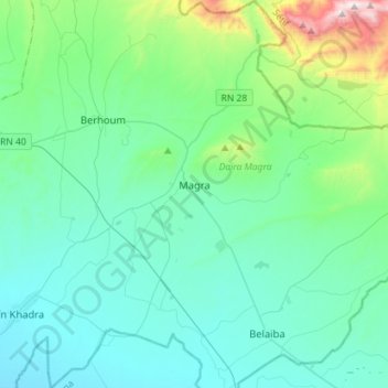
Name: Magra topographic map, elevation, terrain.
Location: Magra, Magra District, M'Sila, Algeria (35.49522 4.99368 35.72617 5.23893)
Average elevation: 2,044 ft
Minimum elevation: 1,378 ft
Maximum elevation: 5,571 ft
Make a donation
Gear up for your next adventure:
As an Amazon Associate, this site earns from qualifying purchases at no extra cost to you.
Other topographic maps
Click on a map to view its topography, its elevation and its terrain.