
Make a donation
Gear up for your next adventure:
As an Amazon Associate, this site earns from qualifying purchases at no extra cost to you.
Barton-le-Clay topographic map
Click on the map to display elevation.
Make a donation
Gear up for your next adventure:
As an Amazon Associate, this site earns from qualifying purchases at no extra cost to you.
About this map
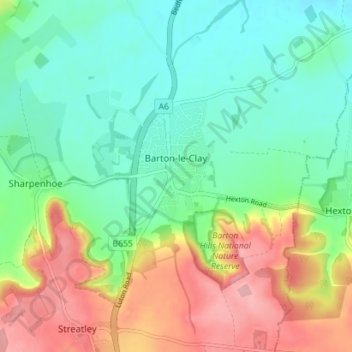
Name: Barton-le-Clay topographic map, elevation, terrain.
Location: Barton-le-Clay, Central Bedfordshire, England, United Kingdom (51.94342 -0.45696 51.98686 -0.39891)
Average elevation: 305 ft
Minimum elevation: 164 ft
Maximum elevation: 554 ft
Make a donation
Gear up for your next adventure:
As an Amazon Associate, this site earns from qualifying purchases at no extra cost to you.
Other topographic maps
Click on a map to view its topography, its elevation and its terrain.
Redlodge Plantation
United Kingdom > England > Central Bedfordshire > Woburn
Average elevation: 400 ft
Little Billington
United Kingdom > England > Central Bedfordshire > Great Billington > Little Billington
Average elevation: 302 ft
Make a donation
Gear up for your next adventure:
As an Amazon Associate, this site earns from qualifying purchases at no extra cost to you.