
Make a donation
Gear up for your next adventure:
As an Amazon Associate, this site earns from qualifying purchases at no extra cost to you.
Al-Hidd topographic map
Click on the map to display elevation.
Make a donation
Gear up for your next adventure:
As an Amazon Associate, this site earns from qualifying purchases at no extra cost to you.
Al-Hidd
Hidd lies south of the Bahrain International Airport and Arad. Situated close by is East Hidd City, a large public housing project under construction. The Shaikh Khalifa Causeway connects Hidd to Juffair on Bahrain Island. The altitude of Al Hidd is 3m.
Make a donation
Gear up for your next adventure:
As an Amazon Associate, this site earns from qualifying purchases at no extra cost to you.
About this map
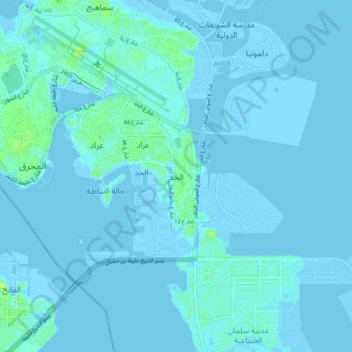
Name: Al-Hidd topographic map, elevation, terrain.
Location: Al-Hidd, Muharraq Governorate, 101, Bahrain (26.20405 50.61289 26.28405 50.69289)
Average elevation: 3 ft
Minimum elevation: -16 ft
Maximum elevation: 46 ft
Make a donation
Gear up for your next adventure:
As an Amazon Associate, this site earns from qualifying purchases at no extra cost to you.
Other topographic maps
Click on a map to view its topography, its elevation and its terrain.