
دهستان جم topographic map
Interactive map
Click on the map to display elevation.
About this map
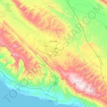
Name: دهستان جم topographic map, elevation, terrain.
Location: دهستان جم, بخش مرکزی, Jam County, Bushehr Province, Iran (27.66590 52.18652 27.94079 52.54160)
Average elevation: 1,932 ft
Minimum elevation: -3 ft
Maximum elevation: 5,069 ft
Other topographic maps
Click on a map to view its topography, its elevation and its terrain.
Jam
Iran > Bushehr Province > Jam County > دهستان جم
Jam, دهستان جم, بخش مرکزی, Jam County, Bushehr Province, Iran
Average elevation: 2,241 ft