
Thank you for supporting this site ❤️
Make a donation
Make a donation
Gear up for your next adventure:
As an Amazon Associate, this site earns from qualifying purchases at no extra cost to you.
Peroblasco topographic map
Click on the map to display elevation.
Thank you for supporting this site ❤️
Make a donation
Make a donation
Gear up for your next adventure:
As an Amazon Associate, this site earns from qualifying purchases at no extra cost to you.
About this map
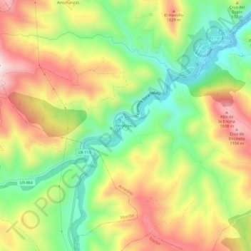
Name: Peroblasco topographic map, elevation, terrain.
Location: Peroblasco, Munilla, La Rioja, 26589, España (42.17845 -2.27771 42.21845 -2.23771)
Average elevation: 2,864 ft
Minimum elevation: 2,146 ft
Maximum elevation: 3,704 ft
Thank you for supporting this site ❤️
Make a donation
Make a donation
Gear up for your next adventure:
As an Amazon Associate, this site earns from qualifying purchases at no extra cost to you.