
Thank you for supporting this site ❤️
Make a donation
Make a donation
Gear up for your next adventure:
As an Amazon Associate, this site earns from qualifying purchases at no extra cost to you.
Rogliano topographic map
Click on the map to display elevation.
Thank you for supporting this site ❤️
Make a donation
Make a donation
Gear up for your next adventure:
As an Amazon Associate, this site earns from qualifying purchases at no extra cost to you.
About this map
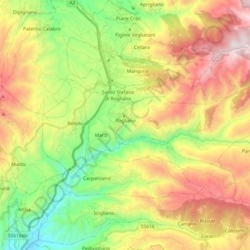
Name: Rogliano topographic map, elevation, terrain.
Location: Rogliano, Cosenza, Calabria, 87054, Italy (39.15278 16.31042 39.19936 16.48516)
Average elevation: 2,484 ft
Minimum elevation: 571 ft
Maximum elevation: 4,964 ft
Thank you for supporting this site ❤️
Make a donation
Make a donation
Gear up for your next adventure:
As an Amazon Associate, this site earns from qualifying purchases at no extra cost to you.