
Thank you for supporting this site ❤️
Make a donation
Make a donation
Gear up for your next adventure:
As an Amazon Associate, this site earns from qualifying purchases at no extra cost to you.
Zwedru topographic map
Click on the map to display elevation.
Thank you for supporting this site ❤️
Make a donation
Make a donation
Gear up for your next adventure:
As an Amazon Associate, this site earns from qualifying purchases at no extra cost to you.
About this map
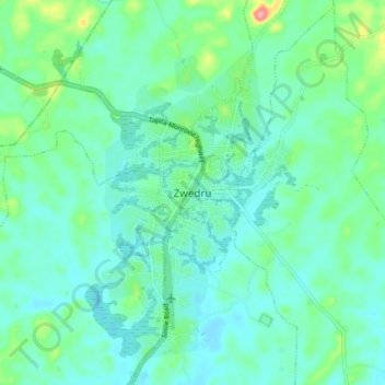
Name: Zwedru topographic map, elevation, terrain.
Location: Zwedru, Zone 2, Tchien, Grand Gedeh County, Liberia (6.02872 -8.17427 6.10872 -8.09427)
Average elevation: 702 ft
Minimum elevation: 633 ft
Maximum elevation: 955 ft
Thank you for supporting this site ❤️
Make a donation
Make a donation
Gear up for your next adventure:
As an Amazon Associate, this site earns from qualifying purchases at no extra cost to you.