
Make a donation
Gear up for your next adventure:
As an Amazon Associate, this site earns from qualifying purchases at no extra cost to you.
Kulpin topographic map
Click on the map to display elevation.
Make a donation
Gear up for your next adventure:
As an Amazon Associate, this site earns from qualifying purchases at no extra cost to you.
Kulpin
Die Relief im Gemeindegebiet ist geprägt durch die Hügel der Jungmoränenlandschaft des Östlichen Hügellands. Es steigt bis auf Höhenlagen von bis zu 52,6 Meter über NHN an. Der Kulpiner See wird gespeist vom Einhäuser Graben.
Make a donation
Gear up for your next adventure:
As an Amazon Associate, this site earns from qualifying purchases at no extra cost to you.
About this map
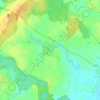
Name: Kulpin topographic map, elevation, terrain.
Average elevation: 154 ft
Minimum elevation: 95 ft
Maximum elevation: 236 ft
Make a donation
Gear up for your next adventure:
As an Amazon Associate, this site earns from qualifying purchases at no extra cost to you.
Other topographic maps
Click on a map to view its topography, its elevation and its terrain.
Rothenhusen
Deutschland > Schleswig-Holstein > Kreis Herzogtum Lauenburg > Groß Sarau
Average elevation: 66 ft
Drüsen
Deutschland > Schleswig-Holstein > Kreis Herzogtum Lauenburg > Lehmrade
Average elevation: 131 ft
Make a donation
Gear up for your next adventure:
As an Amazon Associate, this site earns from qualifying purchases at no extra cost to you.
Dalbekschlucht
Deutschland > Schleswig-Holstein > Kreis Herzogtum Lauenburg > Börnsen
Average elevation: 131 ft